5 BEST Hurricane Ridge Trails in Olympic for Day Hikes

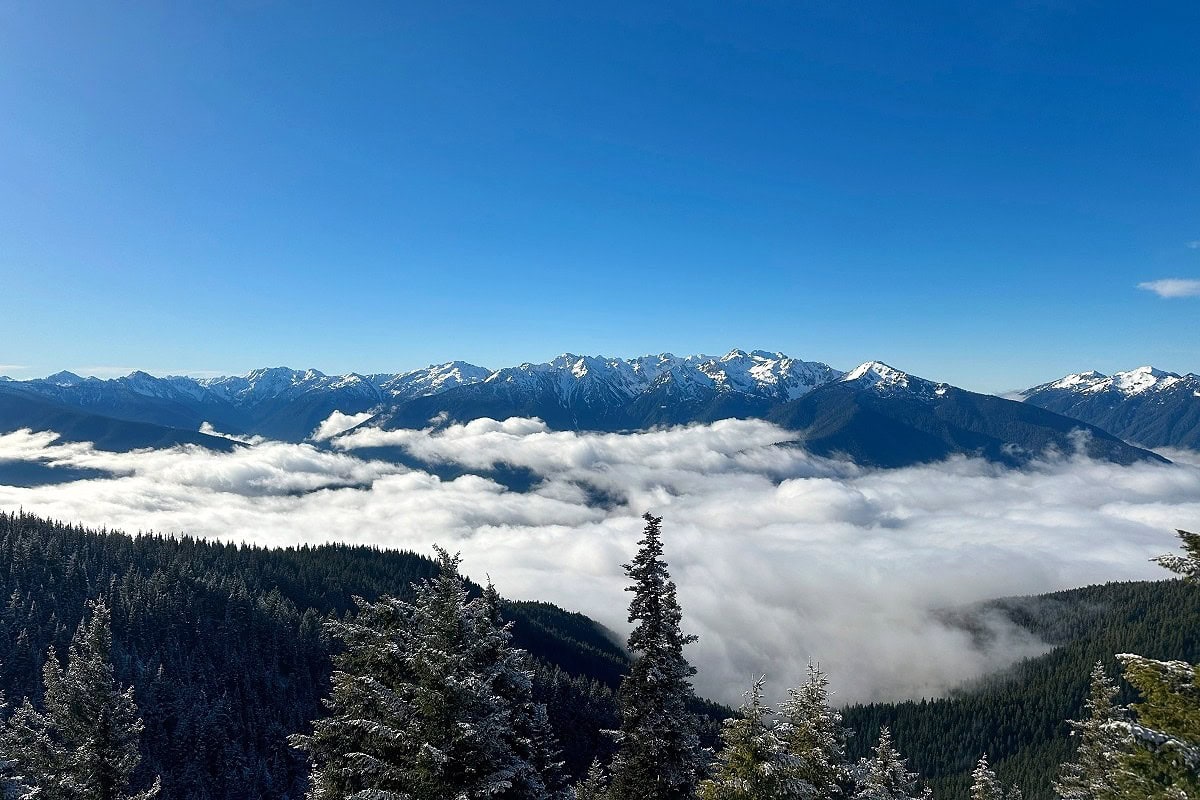
The first time I hiked the Hurricane Hill Trail, low clouds drifted through the valleys beneath the snow-capped Olympic Mountains, creating a dramatic alpine scene I’ll never forget.
I realized then why hiking Hurricane Ridge trails belongs on every Olympic National Park itinerary.
With short paved trails branching off the main parking lot, there’s no more accessible place in the park for panoramic mountain views.
Here are my top 5 trails at Hurricane Ridge for first-time visitors who want the highest return for their effort, and everything you need to know to hike them.
As a local who’s hiked here three times this year alone, I’ll also share planning tips, what to pack, and a map of Hurricane Ridge trailheads—so you’re prepared to hit the trails.
For Experienced Hikers
Hikes off of Obstruction Point Road or to Heather Park are best for experienced adventurers. You’ll get the classic Hurricane Ridge experience on the five trails listed below, without the added risk or commitment of a full-day backcountry hike.
5 Best Hurricane Ridge Trails for First-Timers
If you’re visiting Hurricane Ridge for the first time, these five trails offer the highest reward on a clear day.
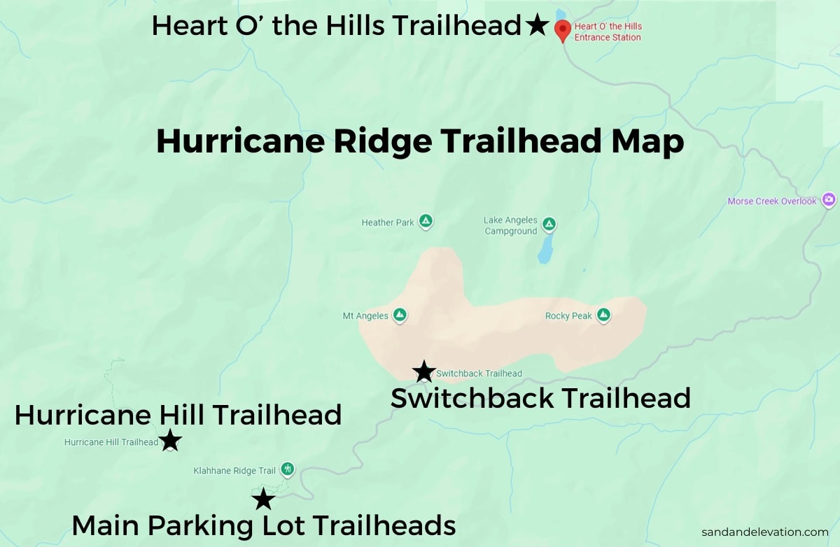
The first and third hikes start from the main parking lot, while the second requires a short drive through the parking lot to reach the trailhead. The fourth starts at the Switchback Trailhead, and the fifth starts at the Heart O’ the Hills Trailhead near the entrance.
I include a trailhead map below.
Need help with trip planning?
I offer custom itinerary planning services to help you save hours (or days!) of research and plan your trip with confidence.
1. Best Easy Hike: High Ridge Trail to Sunrise View Point
- Hike length: 1 mile
- Elevation gain: 220 feet
The High Ridge Trail is short, but you’ll climb 220 feet to reach Sunrise Viewpoint.
If you have only 30-60 minutes, this is the best easy hike at Hurricane Ridge. If hiking 220 feet isn’t doable, stick to the Cirque Rim Nature Trail or the Big Meadow Nature Trail.
Wildlife encounters are common here. My husband Colby and I spotted a group of grouse and two deer wandering the meadows as we walked on the paved connector trail.
From there, you’ll continue up a steep but manageable incline to the first viewpoint. The mountains unfold in dramatic layers, glowing in shades of blue and blanketed in evergreens.

Rugged rocks and evergreen trees frame the trail as you climb higher to Sunrise Point.
At the top, the view opens to the north, where you’ll see downtown Port Angeles and Ediz Hook stretching into the Strait of Juan de Fuca.
➜ Many visitors stay in downtown Port Angeles, minutes from the road to Hurricane Ridge. Check hotel rates and availability here.
2. Best Easy to Moderate Hike: Hurricane Hill
- Hike length: 3.4 miles
- Elevation gain: 830 feet
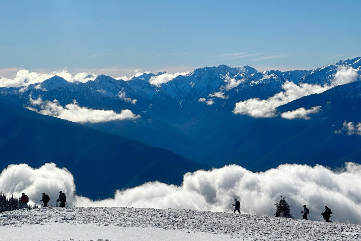
Hurricane Hill is the most popular hike at Hurricane Ridge, excellent in all seasons.
The 3.4-mile round-trip trail is paved, making it accessible for most hikers, though I still huff and puff when climbing the steeper sections.
I hiked it on a winter trip to Olympic when the road to the trailhead was closed, so we walked in from the main lot. The blue-sky day made the climb unforgettable, especially as clouds settled into the valleys beneath snow-covered peaks.
In summer and early fall, you’ll drive past the main lot to park at the trailhead. A bathroom and picnic tables are available.
Benches along the hike offer perfect spots to pause and take in the scenery when you need to take a break.
From the top, the views stretch in every direction—Mount Baker to the east, the Puget Sound, and the extraordinary mountain landscape.
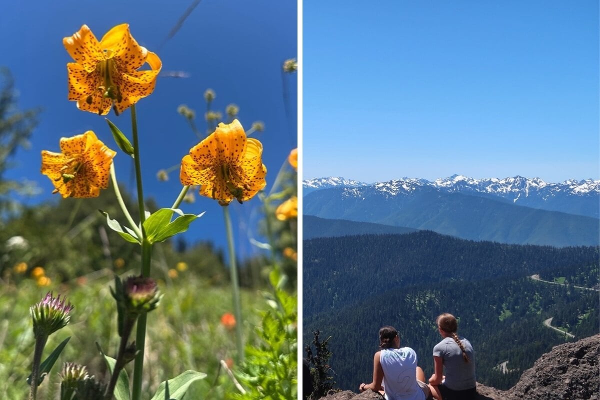
3. Best Moderate to Hard Hike: Hurricane Ridge to Klahane Ridge
- Hike length: 7 miles
- Elevation gain: 2,045 feet
If you’re looking to escape the crowds, the Hurricane Ridge to Klahane Ridge Trail is a standout. We passed only a handful of groups the entire way.
The trail has a few steep sections, but Colby, who’s not a hardcore hiker, said it never felt overly strenuous thanks to the steady pacing.
Wildlife added to our experience—chipmunks darted across the trail, crickets leapt around us and chirped, and moths fluttered through the alpine air.
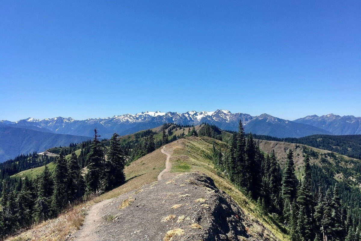
Expect to stop often at viewpoints that reveal mountains stretching endlessly in every direction.
From my favorite viewpoint, you stand in what feels like the center of a 360-degree panorama, making this one of the best hikes on the Olympic Peninsula.
To the left, the iconic Olympic Mountains backdrop dominates, while to the right, yellow grasses, ridgelines, and clustered evergreens unfold against a blue horizon.
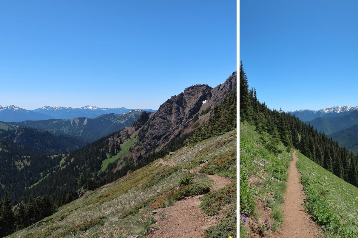
4. Best from Switchback Trailhead: Klahane Ridge via Switchback Trail
- Hike length: 3 miles (option to hike farther)
- Elevation gain: 1,480 feet
With only 8-10 parking spots, I recommend taking the seasonal Hurricane Ridge shuttle since it drops you off close to the Switchback trailhead.
The climb begins zigzagging steeply uphill through the forest just as its name promises.
Most hikers stop where the Switchback Trail meets Klahane Ridge, a rocky perch perfect for a snack and sweeping views.
On my hike, I continued farther onto the Klahane Ridge Trail and was rewarded with a moment I’ll never forget—two eagles looping gracefully at eye level with the Olympic Mountains as their backdrop.
The farther you go along Klahane Ridge, you’ll encounter undulating sections that are steep and exposed, with scree and lingering snow in late June.
Views extend in every direction on this hike—Mount Baker across the water, the Port Angeles waterfront, and even Vancouver Island on a clear day.
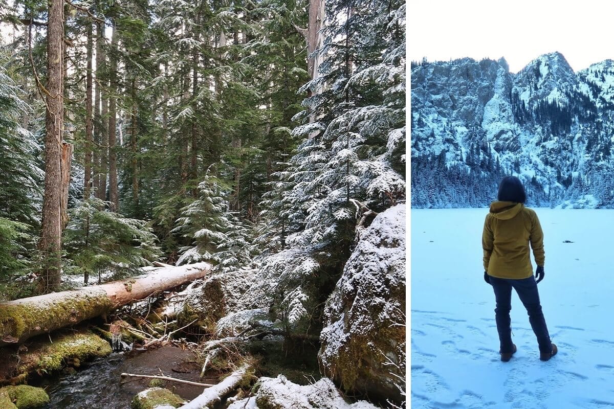
5. Best from Heart O’ the Hills Trailhead: Lake Angeles Trail
- Hike length: 7 miles
- Elevation gain: 2,480 feet
The Lake Angeles Trail begins at the Heart O’ the Hills Trailhead, near the entrance station.
The trail climbs through second-growth forest, where fallen logs and the sound of rushing water set the tone.
When we hiked Hurricane Ridge in winter, snow draped the trees, and icicles hung from branches. Seeing Ennis Creek tumbling beneath a log bridge while snow covered the landscape felt like hiking through a winter wonderland.
Reaching Lake Angeles is the highlight, and backcountry campers with a permit will stay the night or continue to Heather Park.
We set up chairs on the shore to eat lunch, grateful for the chance to rest and take in the alpine views.
In winter, the lake freezes, reflecting the surrounding snow-dusted peaks. The contrast of gray rock faces topped with bright white snow and sunlit evergreens made the setting spectacular.
Where to Find the Hurricane Ridge Trailhead & Map
The Cirque Rim, Big Meadow, and High Ridge trails start from the ridge’s main parking lot on paved pathways. You can’t miss them, although they’re not marked at the start.
Cell service is unreliable, so download your AllTrails maps ahead of time. I’ve run into hikers who couldn’t get their maps to load and had to ask for directions, despite having the app on their phone.
Here’s a map which shows the location of the main parking lot, the Hurricane Hill Trailhead, and the Switchback and Heart O’ the Hills trailheads along Hurricane Ridge Road.
Hurricane Ridge Hiking Planning Guide
Start with my complete guide to visiting Olympic National Park to help you plan.
- Park Pass: Purchase one online, at the Heart O’ the Hills entrance station, or at the Olympic National Park Visitor Center.
- Location: 17 miles south of Port Angeles. I stay in Port Angeles when I want to get an early start at the ridge. It’s the best home base to explore the park’s northern attractions.
- How to Get Here: Drive the scenic Hurricane Ridge Road or you can let someone else drive, like I like to do, by taking the seasonal public shuttle from Port Angeles.
- Amenities: Restrooms, picnic tables, benches, and potable water near the main parking lot. You can’t buy food here, so consider stopping at Country Aire downtown before your visit.
- Accessibility: Short, paved walkways available from the parking lot.
- Pets Allowed: Pets are not allowed on paved or dirt trails.
- Best Season to Hike: Summer and early fall (mid-late June through September) are the best times for snow-free trails and clear views. Arrive by 8am or after 4pm to get a parking spot in peak season.
- When & Where to See Wildflowers: Late June through mid-late July in meadows surrounding the main parking lot and along trails. I caught Columbia lily at peak bloom on a late June hike up the Switchback Trail.
➜ Wondering where to stay before hiking? Check out my guide to the best places to stay in Port Angeles.
What to Pack for Hiking at Hurricane Ridge
Here’s a short list of essentials for hiking in Olympic National Park.
- Backpack: I only use backpacks with a hip belt to take weight off my shoulders—it makes a big difference on longer climbs.
- Footwear: Hiking shoes or boots with solid tread are best, especially for steep descents and scree sections.
- Trekking poles: Poles offer stability on uneven terrain. I found them helpful on Klahane Ridge, though I also saw trail runners handling it fine without.
- Accessories: Hurricane Ridge trails are exposed, so I always pack a sun hat, sunglasses, extra sunscreen, and more water than I think I’ll need.
- Winter Footwear: For winter visits, bring microspikes or snowshoes, plus gaiters to keep snow out of your insulated boots.
Always check recent trip reports to see what other hikers were glad they brought for the trail you plan to hike.

Where to Go Next on Your Olympic National Park Itinerary?
After a trip to Hurricane Ridge, you’ll have plenty of choices for what to do next.
- Stay in Port Angeles: Use it as your base for exploring beaches, waterfront trails, or downtown restaurants and breweries.
- Head west: Take a day trip to the Sol Duc Valley for waterfalls and hot springs, or stop at Lake Crescent for lakeside views—or the challenging Mount Storm King hike.
If you’d like expert local advice, I can help craft a custom itinerary to make sure you see the best of Olympic National Park.

Skip the guesswork, stress, and hours of research—let me help you plan your itinerary!